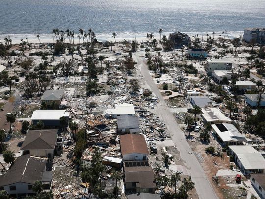
Hurricane Ian — one of the most powerful storms to hit the United States — has left a trail of destruction across the US state of Florida, killing at least 19 people. Officials expect the death toll to rise. As a massive search and rescue operation continues in Florida, where it made landfall, the category one storm has moved inland and is heading towards North and South Carolina.
Hurricanes, cyclones and typhoons: what are they? What’s the difference? Here’s a look at the killer storms, their names and more.
What’s a hurricane?
The word hurricane is believed to have derived from the indigenous term hurakan, which signifies evil spirits and weather gods. Hurakan was used by European explorers centuries back to describe the storms that hammered their ships in the Caribbean, according to National Geographic.
Hurricane is one of three names for massive, rotating tropical storms with winds of at least 119 kilometres per hour (kmph).
Hurricane, typhoon, cyclone: what’s the difference?
Hurricanes, cyclones and typhoons are rotating storms with maximum sustained winds of 119 kmph or higher. The storms in the North Atlantic, central North Pacific or eastern North Pacific are called hurricanes, while in the Northwest Pacific, it’s considered a typhoon. The term tropical cyclone is used in the South Pacific or the Indian Ocean.
Typhoons with wind speeds of 241 kmph or more are called “super typhoons”. When a tropical cyclone pack winds between 62 kmph and 119 kmph, it is classified as a tropical storm. Winds below that are called tropical depressions.
A tornado is different: it’s a funnel cloud that forms from a storm over land. Tornadoes are much smaller in scale than hurricanes. They can sometimes be a part of a hurricane.
Why are tropical storms dangerous?
Tropical storms, irrespective of their names, carry winds of over 119 kmph, which can devastate coastal areas, leading to massive death tolls. They can damage buildings and trees.
When a hurricane makes landfall, it produces a devastating storm surge — a wall of ocean water pushed ashore by wind — that can reach six metres high and move several kilometres inland, according to a Nasa report.
Storm surges and flooding are the two most dangerous aspects of hurricanes, accounting for three-quarters of deaths from Atlantic tropical cyclones, according to a 2014 study. So many people drown during flooding because they don't realise the power of water. Six inches of fast-moving flood water is enough to knock down an adult. It takes only two feet of rushing water to carry away most vehicles, including pickups and SUVs, according to US National Oceanic and Atmospheric Administration.
A hurricane’s high winds are destructive and may spawn tornadoes. Torrential rains cause more damage through flooding and landslides, which may occur many kilometres inland.
How are tropical storms formed?
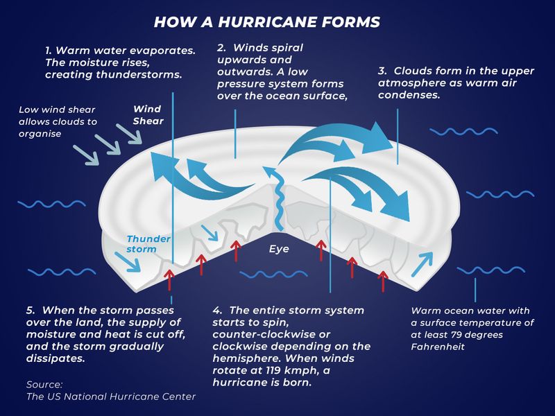
They begin as tropical disturbances or low-pressure systems in warm ocean waters with temperatures of at least 26 degrees Celsius (79 degrees Fahrenheit). The low-pressure systems are fed by energy from warm seas.
A tropical disturbance can become a tropical depression — an area of rotating thunderstorms with winds of 62 kmph or less. When it becomes a tropical storm with sustained wind speeds of over 63 kmph, it is given a name according to conventions of the World Meteorological Organisation.
How does a storm become a hurricane?
A tropical depression becomes a tropical storm when its winds reach 63 kmph. And a tropical storm can turn into a hurricane if winds top 119 kmph). Hurricanes draw heat from the warm, moist ocean air and release it through condensation of water vapour in thunderstorms, according to a Nasa report.
How are hurricanes formed?
Two main ingredients for a hurricane to form are warm water and winds. Warm ocean waters provide the energy for a storm to transform into a hurricane. A surface water temperature of 26 degrees Celsius (79 degrees Fahrenheit) or higher is required for a hurricane to form.
Winds that don’t vary in speed or direction as they go up allow the hurricane to gather momentum. If wind speeds vary, the storms will dissipate.
Hurricane spin: clockwise or anti-clockwise?
The Coriolis force, caused by the earth’s rotation, pulls the air to the right (counterclockwise) in the northern hemisphere and the left (clockwise) in the southern hemisphere. So hurricanes spin anti-clockwise in the northern hemisphere and clockwise in the southern hemisphere.
Since the Coriolis force is too weak to act on the moving air at the equator, storms and hurricanes are not observed there. The Coriolis force pulls hurricanes away from the equator, so hurricanes can form 5 degrees above the equator.
When is the peak season for hurricanes and cyclones?
The peak season for Atlantic Ocean’s hurricanes is from mid-August to late October, averaging five to six hurricanes each year. Cyclones on the northern Indian Ocean tend to form between April and December, with peak activity around May and November.
How are the storms named?
Since there can be more than one hurricane at a time, each hurricane is named to make tracking and talking about the storms easier. Tropical disturbances and depressions are not given names.
A tropical storm gets a name that stays even if it becomes a hurricane. Every year, a new list of names is used, and tropical storms are named in alphabetical order. These lists are reused every six years.
If a storm wreaks massive damage and if its name is taken off the list, a new name with the same letter is added to the list.
Which are the most powerful storms?
The most powerful tropical cyclones on record have been formed in the Pacific since there is more room to grow stronger before landfall.
Hurricane Patricia, which formed in the eastern Pacific off Guatemala in 2015, had the strongest winds recorded, at 346 kmph. The strongest Atlantic storm was Wilma in 2005, with winds of 294 kmph.
By wind speed, Hurricane Ian is the fifth most powerful storm to ever hit the US. Only four other hurricanes have made landfall with sustained winds of more than 155mph.
Is climate change fuelling hurricanes?
Climate change is making hurricanes wetter and more intense, evidence shows. It is causing storms to travel more slowly and dump more water in one place, a Reuters report said.
In the last 40 years, the ocean has absorbed about 90 per cent of the warming caused by greenhouse gas emissions. Since much of the heat is contained near the water’s surface, it drives a storm’s intensity and power stronger winds.
Climate change can also increase the rainfall from a storm: a warmer atmosphere holds more moisture, and water vapour builds up until clouds cool, sending down heavy rain.
The Atlantic hurricane season of 2020 was one of the most active on record, and climate change increased hourly rainfall rates in hurricane-force storms by 8-11 per cent, according to a study in the journal Nature Communications.
Has climate change impacted hurricane season?
The typical hurricane season has been shifting as global warming creates optimal conditions for more storms to form each year. Hurricanes have also been making landfall in regions far from the regular spots.
In the United States, more hurricanes make landfalls in Florida, with more than 120 direct hits recorded since 1851, according to the US National Oceanic and Atmospheric Administration (NOAA). In recent years, some storms have been making landfall farther north, and scientists attribute the poleward shift to rising global air and ocean temperatures.
Hurricane activity in North America runs from June through November, peaking in September, but currently, the storms tend to make landfalls more than three weeks earlier than they did in 1900, according to a study published in Nature Communications.
A similar trend is witnessed in Asia’s Bay of Bengal, where cyclones have been forming earlier than usual in April and May since 2013, according to a study in Scientific Reports.
Will hurricanes become more powerful in future?
Scientists recently reported a rise in the frequency of North Atlantic hurricanes over the last 150 years, according to a study published in Nature Communications.
The world has warmed 1.1 degrees Celsius above the preindustrial average, and scientists say at 2C of warming, hurricane wind speeds could increase by up to 10 per cent.
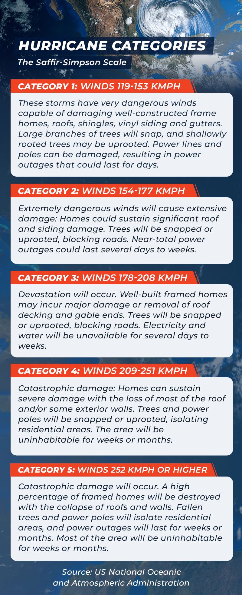
This has prompted the US National Oceanic and Atmospheric Administration to project that the proportion of hurricanes reaching Category 4 or 5 could rise by about 10 per cent this century. That’s a scary prospect since less than a fifth of storms have reached this intensity since 1851.
More From Special-Reports


How family tradition shaped my personal connections

The lost art of handwritten letters