Dubai: Hope Probe, the first Arab interplanetary mission, has completed its commissioning and testing phase and is ready to transition to science orbit, Emirates Mars Mission (EMM) Project Director Omran Sharaf announced on Tuesday.
“We have completed twenty-one orbits of Mars since we arrived at the Red planet on the evening of February 9. We’ve been busy calibrating Hope Probe’s three instruments, commissioning and testing the spacecraft’s instrumentation subsystems and using every opportunity to gather data while we’ve been in our capture orbit,” Sharaf said. He also noted the completion of testing is ahead of schedule and the transition to science manoeuvres will take place earlier than planned.
Scientific study
EMM also released on Tuesday the first full suite of Martian images taken by the Hope Probe’s three science instruments. The instruments will take photos of Martian atmosphere to study the link between weather change and atmospheric loss, a process that may have caused the Red Planet’s surface corrosion and the loss of its upper atmosphere.
For the first time, the mission will provide deeper insights on the climatic dynamics of the Red Planet through observing the weather phenomena in Mars such as the massive famous dust storms that have been known to engulf the Red Planet, as compared to the short and localised dust storms on earth. It will focus on better understanding the link between weather changes in Mars’ lower atmosphere, with the loss of hydrogen and oxygen from the upper layers of the atmosphere.
Capture orbit
After successfully entering Mars orbit on February, Hope Probe remained at its elliptical capture orbit, travelling as close as 1,063 kilometres to Mars’ planetary surface and as far away as 42,461 kilometres. While at this orbit, Hope Probe has so far captured over 825 images of Mars using its three instruments, generating some 30 GB of novel data on Mars’ atmospheric make-up.
EMM Science Lead Hessa Al Matroushi said: “We have already amassed a library of some 280,000 spectra of Mars using the Emirates Mars Infrared Spectrometer (EMIRS) alone. We have also been able to take a range of highly detailed images of the planet using our imager, helped by the fact that when we’re at our closest point in our orbit, we’re on the sunny side of Mars. We’re very excited indeed now to be moving to our science orbit and starting the flow of planetary data we aim to gather over the coming Martian year.”
Science manoeuvres
Before entering the science orbit, where Hope Probe will commence with its core mission of data gathering, the ground control at Mohammed bin Rashid Space Centre (MBRSC) will conduct two Transition to Science Manoeuvres (TSMs) to move the probe from its capture to science orbit.
The first TSM will commence on March 22 and the second TSM is on April 6. A third manoeuvre, originally planned by the team, will not be needed, according to Sharaf. He said: “Our Mars Orbit Insertion was highly successful and precisely targeted and this has allowed us to plan a reduction in TSMs and also to move to our science orbit ahead of schedule.
“We will commence science data gathering earlier in April than we had originally planned and I think it’s fair to say there is huge excitement now in our science team and among Mars scientists around the world,” Sharaf added.
Science orbit
Hope has a planned 20,000-43,000km elliptical science orbit, with an inclination to Mars of 25 degrees. The probe will complete one orbit of the planet every 55 hours and will capture a full planetary data sample every nine days.
* EMIRS — The Emirates Mars Infrared Spectrometer measures the global distribution of dust, ice cloud, and water vapour in the Martian lower atmosphere.
* EMUS — The Emirates Mars Ultraviolet Spectrometer measures oxygen and carbon monoxide in the thermosphere and the variability of hydrogen and oxygen in the upper atmosphere.
In an earlier interview with Gulf News, Omran Ahmed Al Hammadi, Hope Probe Science Data Centre Lead, said the first set of data that will be released to the scientific community and the public will be by September. “The mission operation centre at different ground stations spread around the world will receive raw data from Hope Probe, which will be submitted to the Science Data Centre at MBRSC, where data processing, management and indexing will be done. It will take 30 minutes to process the data and the first set of data will be released by September and every three months thereafter,” he added.
Autonomous spacecraft
Hope Probe is a fully autonomous spacecraft, carrying three instruments to measure Mars’ atmosphere. Weighing some 1,350kg, and approximately the size of a small SUV, the spacecraft was designed and developed by MBRSC engineers working with academic partners, including the Laboratory for Atmospheric and Space Physics at the University of Colorado, Boulder; Arizona State University and the University of California, Berkeley.
First full suite of Martian images
On Tuesday, EMM released the first full suite of Martian images taken by the Hope Probe’s three science instruments spanning visible, ultra violet and infrared spectra.
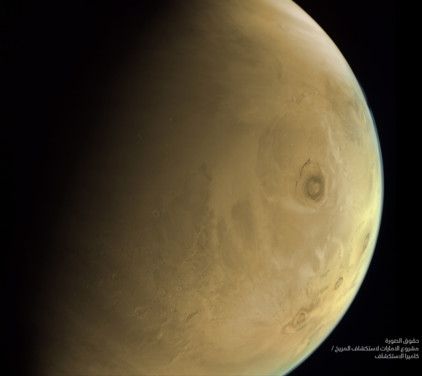
The Emirates eXploration Imager (EXI) captured Olympus Mons, the tallest volcano in the solar system, at 9:33 UTC on February 26 from an altitude of 13,007km. North is towards the top right of the image. The colour is created from a composite of the red, green and blue EXI images. The summit of Olympus Mons is 21km above the Mars global datum (zero level elevation).
For perspective, that is about two and a half times the height of Mount Everest above sea level. Olympus Mons is the youngest of the large volcanoes on Mars forming during the Hesperian Period (~3,700 to ~3,000 million years ago), which roughly corresponds to the Archaean Period on Earth. It was likely built by thousands of highly fluid basaltic lava flows over long periods of time. On Earth, the shield volcanoes of the Hawaiian Islands have been used as an analogue for understanding the volcanic processes that created Olympus Mons and other shield volcanoes on Mars, albeit on a much smaller scale.
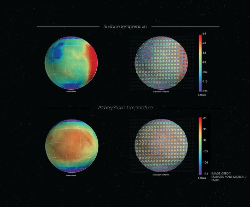
The images from EMIRS captured mostly the Martian nightside (purple-green-blue hues), though dawn can be seen on the right-hand side of the surface temperature image (red hues). Features such as Arabia Terra (low thermal inertia and thus cold night-time temperatures) can be observed in the upper left portion of the surface temperature data. EMIRS measurement footprints were mapped to the planet, colourised by temperature, and overlain on a Mars Orbiter Laser Altimeter (MOLA) shaded relief map (right column). Data between footprints were also interpolated, colourised, and overlain on MOLA shaded relief to form a continuous image (left column).
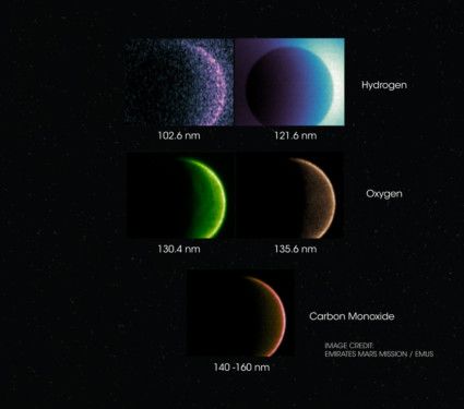
Meanwhile, false-colour images of Mars were obtained by the Emirates Ultraviolet Spectrometer (EMUS) from an altitude of 36,000km above the Martian surface. Each colour represents light collected at a different ultraviolet wavelength and provides unique information about the Martian upper atmosphere, at the edge of space. Images from left to right (with respective wavelengths in nanometres):
Violet (102.6 nm) and blue (121.6 nm) show the reflection of sunlight from the extended cloud of hydrogen atoms surrounding the planet.
Green (130.4 nm) shows the reflection of sunlight from oxygen atoms in the upper atmosphere.
Orange (135.6 nm) shows energetic electrons causing other oxygen atoms to glow, similar to a fluorescent lamp.
Red (140-160 nm) shows a combination of emissions coming from carbon monoxide molecules.


