Manila: Nasa has called the string of storms swirling near the Philippines this November “unusual” – even as researchers warn that future Philippine typhoons could further intensify.
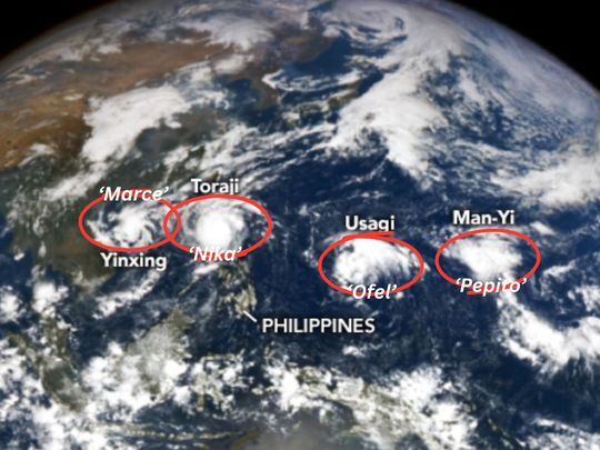
On Thursday, the US space agency released a striking satellite image capturing a parade of four tropical cyclones — Marce, Nika, Ofel, and Pepito — lined up across the western Pacific on November 11.
At that moment, the storms were either barreling toward the Philippines or had already swept over parts of Luzon.
“In a rare sight, four storms churned simultaneously in the Western Pacific Ocean in November 2024,” Nasa reported.
First time on record
While typhoon season in the West Pacific typically spans the entire year, the majority of storms form between May and October. That's what makes the four cyclones simultaneously threatening Philippines unusual.
“November usually sees about three named storms, with one potentially intensifying into a super typhoon,” Nasa added, citing historical data from 1991 to 2000.
The Japan Meteorological Agency (JMA) noted it was the first time since records began in 1951 that so many storms co-existed in the Pacific basin during November.
Intensity: Near “supertyphoon” speed on Saturday
Affected areas: Southern, central and northern Luzon, including Metro Manila (Saturday to Sunday)
Worst-case scenario: Pepito could gain “supertyphoon” speed, hit Manila at up to Signal No. 4
Relentless wave
The relentless wave of weather disasters this November has already claimed 159 lives in the Philippines, prompting the United Nations to appeal for $32.9 million in emergency aid for the hardest-hit areas.
Nika made landfall in Aurora province, triggering widespread flooding, power outages, and landslides that blocked roads in the Cordilleras. Ofel then struck the disaster-weary northern Philippines, forcing thousands of residents to evacuate.
Pepito: Latest storm “overlap”
Meanwhile, Typhoon Pepito (Mang-yi, which has a radius of 380 km from the centre) has intensified in the western Pacific, reaching “near-super typhoon” status as of Saturday morning (November 16).
By 5pm on Saturday (November 16), Pepito’s eye was seen at 160 km east of Legazpi City, Albay in eastern Philippines at “near super-typhoon” wind speed of 185 km/h, moving west-north-west at 20 km/h.
Philippine weather bureau Pagasa has cautioned that it could reach its peak intensity before making landfall in eastern Bicol or Central Luzon, following a similar trajectory to last month’s severe tropical storm Kristine, which caused most of the recent fatalities.
Typhoons usually intensify as they travel over a water body — depending on oceanic and environmental conditions.
“Typhoons are coming one after another. Just as communities begin to recover, another storm hits,” said Gustavo Gonzalez, the UN's humanitarian coordinator in the Philippines.
“This overlap exhausts response capacities and depletes budgets.”
A UN assessment revealed that the severe weather over the past month has damaged or destroyed 207,000 homes, leaving nearly 700,000 people seeking temporary shelter.
'Stronger', 'slower' storms
Meanwhile, a new study warns of stronger, slower storms, escalating damage and increasing risks for vulnerable communities, due to the reality of climate change.
Research published by the Institute of Environmental Science and Meteorology at the University of the Philippines – Diliman College of Science (UPD-CS), in collaboration with UK colleagues posits that future typhoons in the Philippines could have a significantly higher Cyclone Damage Potential (CDP) than current ones.
Damage metric
CDP is a key metric that factors in the size of the cyclone and the speed of its winds, providing an estimate of potential damage costs, especially from strong winds.
A team led by Dr. Gerry Bagtas team analysed three of the most devastating super typhoons in recent history: Haiyan (Yolanda, 2013), Bopha (Pablo, 2012), and Mangkhut (Ompong, 2018).
Modelling
Using climate projections for the years 2070 to 2099, they modeled the potential impact of these typhoons in a future climate expected to be warmer and more humid.
The weather service said this tends to happen during seasonal episodes of La Niña, a climatic phenomenon in the Pacific Ocean that pushes more warm water toward Asia, causing heavy rains and flooding in the region and drought in the southern United States.
Improving typhoon prediction
A study published in Nature Communications (2021) demonstrated how machine learning models could significantly enhance the accuracy of tropical cyclone predictions. Researchers integrated data from satellite imagery, sea surface temperatures, and historical storm paths into a deep learning framework.
The model was able to predict the intensity and trajectory of typhoons more accurately than traditional meteorological models, particularly for rapidly-intensifying storms, which are often the most challenging to forecast.
Improved prediction capability allows for better preparation and early warnings – crucial in minimising damage and loss of life during typhoon events.
AI in climate impact assessment, mitigation
Another study conducted by the Massachusetts Institute of Technology (MIT) in 2022 explored the role of AI in assessing the effects of climate change on typhoon patterns. Using a combination of neural networks and climate models, the researchers were able to identify shifts in typhoon frequency and intensity linked to global warming.
The AI models helped in understanding complex climate interactions, allowing policymakers to better anticipate extreme weather events and implement adaptive measures.
A more refined simulation improves the modeling of extreme values for wind, temperature, and humidity, which typically have significant errors in coarse scale models.
Use cases
By integrating machine learning with dynamical systems theory, the MIT team's approach "nudges" climate model simulations toward more realistic large-scale patterns. When combined with smaller-scale models to forecast specific weather events like tropical cyclones or floods, this method delivered more accurate predictions of the frequency of such events at specific locations over the coming decades, outperforming traditional models that lack this corrective scheme.
MIT-derived algorithm helps forecast the frequency of extreme weather to guide infrastructure development, urban planning, and disaster response strategies, ultimately reducing the socioeconomic impacts of typhoons exacerbated by climate change.


